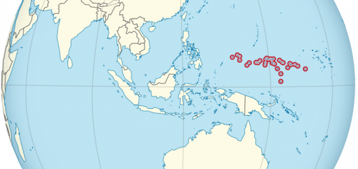
PALAOS (República de Palaos)

De TUBS – Trabajo propioEste gráfico vectorial, sin especificar según el W3C, fue creado con Adobe Illustrator.Este archivo fue subido con Commonist.Esta imagen vectorial incluye elementos que han sido tomados o adaptados de esta: Indonesia on the globe (Southeast Asia centered).svg (de TUBS).Esta imagen vectorial incluye elementos que han sido tomados o adaptados de esta: Australia in Oceania (Ashmore and Cartier Islands special) (small islands magnified) (-mini map -rivers).svg (de TUBS)., CC BY-SA 3.0, https://commons.wikimedia.org/w/index.php?curid=15319003

GENTILICIO: palauano, palauana
CAPITAL: Ngerulmud
IDIOMA OFICIAL: inglés, palauano, japonés, angaur, tobiano, sonsorol
FORMA DE GOBIERNO: República presidencialista apartidista
SUPERFICIE Y PUESTO QUE OCUPA EN EL MUNDO (RANKING TAMAÑO): 459 km2, ocupando el puesto 179º
PUNTO MÁS ALTO: Monte Ngerchelchuus (242 ms)
INFORMACIÓN ADICIONAL SOBRE PALAOS